The 'Spice Islands and Their 'Discovery'
At the beginning of the 16th century there were only a few things that spoke to the European imagination on the same level as the mythical 'Spice Islands' with al their natural riches. Nowadays the spice islands are called the Moluccas. The Moluccan archipel of islands is located in the Banda Sea and roughly lays between the Indonesian island of Sulawesi and New-Guninea. Finding the precise location of these islands, and a direct route to them, was one of the things that the 16th century Eruopeans aspired the most. The 'myth' about the Eastern islands and the quest to finding them can be placed on the same pedestal as the quest to find el Dorado, the illusive city of gold, supposedly located in Latin-America. The Europeans soon realized that the spice islands, contrary to el Dorado, were not a mere product of human imagination. The islands with all their spices were real, and they were waiting to be 'discovered' by the Europeans.
|
Shortly after Afonso de Albuquerque (c. 1453-1515) conquered Malacca for Portugal in 1511, he launched a voyage to find the spice islands. This mission, which was strictly meant for exploration and trade, is the first European voyage that would reach the Moluccas. António de Abreu (c.1480-c.1514) and Francisco Serrão (d. 1521) were the ones that led the mission, but there was another person that went on the exploration mission in the name of king Manuel I of Portugal (1469-1521), namely, Tomé Pires (c. 1465-c. 1540). Pires was an apothecary to the ill-fated Afonso, Prince of Portugal. He went to India in 1511, invested in "factors of drugs," which were the Eastern commodities that were an important element of what is generally called the spice trade.
By order of Manuel I, Tomé Pires had to write a report about his journey to the spice islands. Pires wrote his report in the period 1512-1515 and named his book: Suma Oriental. In this book he describes his journey from Egypt to the Moluccas. It is a compilation of a wide variety of information ranging from historical and ethnographic to commercial and botanical information. The abundance of information also has a more negative tone to it, specifically the information Pires gives us about the inhabitants of the indonesian archipelo and the Moluccas and their commercial trades. The perspective that Pires creates is an orientalistic view of the region, were Portugal can be seen as the center of the world and the Indonesian islands are in Portugal’s periphery. If you analyze global trade and global networks in the early modern world through this specific perspective, you may come to the conclusion that the Indonesian archipelo and the Moluccas had been integrated in the global trading system with the help of Portugal. But isn’t it the other way around? Weren’t it the Indonesian islands, with all their spices, that enabled Portugal to be one of the strongest trading and political powers of the 16th century world? The fact that the Portugeuse empire had possesion of the Indonesian archipelo and the Moluccas ensured Portugal's intergration in the global trade network of the early modern period. If this is the case, to what extent is the Suma Oriental written by Tomé Pires a realistic or fictional representation of the Indonesian and Moluccan trading network in the first 15 years of the 16th century? To answer this question, we must first look at the trading network described by Pires in his Suma Oriental, |

Figure 1: A Portrait of Tomé Pires from his period in China.
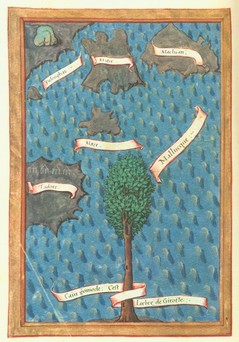
Figure 2: A 'Map' of Five Islands in te Banda Sea Where Cloves Grow (Made by Antonio Pigafetta, 1521)
|
The Suma Oriental and the Trading Network of the Indonesian Archipelo and the Moluccas
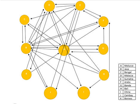
Figure 3: According to the Suma Oriental, the Network of Trading Ties Between the Different Island of South-East Asia and Other Entities of the Region Looks Something Like This
|
The network that Pires describes in the Suma Oriental is an extensive network of the region. An example is that in his description of Java, he describes nineteen different kingdoms that are located in Java. In the case of Sumatra he describes an astonishing thirty-one kingdoms that are located on the island. All these different kingdoms have been fused together in figure 3, and table 1. The reason behind this fusion is that we are interested in the Southeast Asian trading network on a large scale, not the relative small trading network of the different kingdoms within the Islands of Java or Sumatra.
Figure 3 shows the different trading ties between different islands and entities of South-East Asia. According to this figure, Java plays a central role in the trading network of this region. All other nodes, except for node J, I and K, had direct trading ties with Java. Java acts as the central trading point in this network. The other islands trade their commodities with the Javanese, and the Javanese sell it to the kingdoms of Malacca and Bengal. Another fact this figure shows is the role of the Arabs in this trading network. Tomé Pires even states that the Arabs have been trading with the Java since the time of Mohammed. Table 1 shows the differrent commodities each island or kingdom had for trade in this region. The products range from diamonds and gold all the way to parrots and horses. |
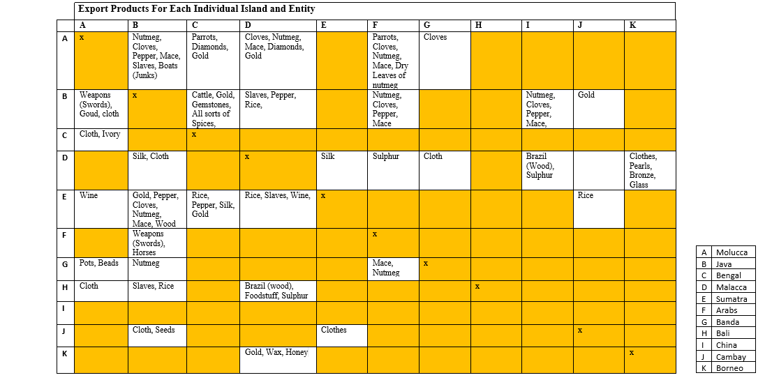
Table 1: Export Products for Each Individual Island and Entity of the South-East Asia According to the Suma Oriental
Pires' Trading Network and Its Precision
Now that the trading network according to the Suma Oriental has veen reconstructed in figure 3, it is time to see how precise it actually was. To check its precision, secondary literature will be used that specifically focuses on trade in the South-East Asian region.
Matt Matsuda states in, Pacific Worlds: a History of Seas, Peoples and Cultures, that the scale of the trading network in the Southeast Asian region is something that cannot be compared to anything in Europe at the time. The dominant traders, according to Matsuda, were the Arabs. In most of the cases they didn't trade directly with the Moluccas; but they bought their spices in Malacca. In the Suma Oriental it appears to be that the Arabs traded directly with the Moluccas and the other spice islands, but this is not the case. When the Arabs bought their spices in Malacca the spices would already been through the hands of multiple traders from Java or Sumatra, before it reached the Arabs. Pires is correct in the fact that the Arabs traded in products that were native to the Moluccas, but he forgets to tell the specific details about how the spices got to the Arabs. The narrative lacks details on this specific point. The same can be said about the gold trade in the region. Pires is right that there was gold in the region and that is was a regular trading commodity, but he does not tell us that the gold is of extremely poor quality. Compared to the gold that comes from Latin-America, the gold that comes from Java and Borneo is worth close to nothing.
Matt Matsuda states in, Pacific Worlds: a History of Seas, Peoples and Cultures, that the scale of the trading network in the Southeast Asian region is something that cannot be compared to anything in Europe at the time. The dominant traders, according to Matsuda, were the Arabs. In most of the cases they didn't trade directly with the Moluccas; but they bought their spices in Malacca. In the Suma Oriental it appears to be that the Arabs traded directly with the Moluccas and the other spice islands, but this is not the case. When the Arabs bought their spices in Malacca the spices would already been through the hands of multiple traders from Java or Sumatra, before it reached the Arabs. Pires is correct in the fact that the Arabs traded in products that were native to the Moluccas, but he forgets to tell the specific details about how the spices got to the Arabs. The narrative lacks details on this specific point. The same can be said about the gold trade in the region. Pires is right that there was gold in the region and that is was a regular trading commodity, but he does not tell us that the gold is of extremely poor quality. Compared to the gold that comes from Latin-America, the gold that comes from Java and Borneo is worth close to nothing.
|
Another flaw of the Suma Oriental is the location of the different spices. According to Pires, nutmeg grows on mutiple islands. In the article "Trade and Society in the Banda Islands in the Sixteenth Century," John Villiers says that this is not true. Villiers says that nutmeg only grows on the Island called Banda in the period that Pires visited the different islands. So, in the time that Pires visited the islands, nutmeg was only cultivated in Banda and nowhere else. Another problem is the fact that Pires does not talk about coins much. According to Villiers, coins were important within the network of the region, especially for the Chinese and Bengals. The network of the Suma Oriental (figure 3), is a network based on barter. This means that a person trades cloth for pepper and that no coins come into play during the trade. Villiers states that this is not true and that much of the trade, especially the trade between the large kingdoms, was done with copper coins called caixas in Portugeuse. |
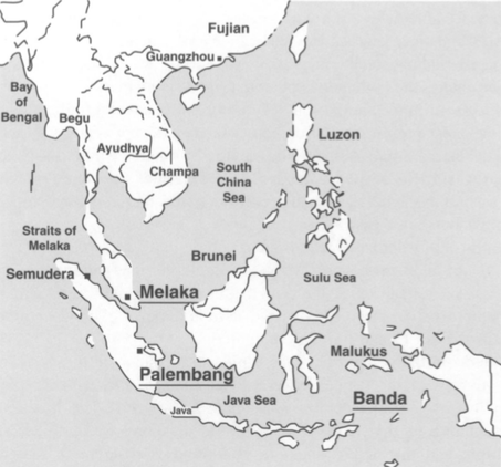
Figure 4: Map of South-East Asia and Its Different Kingdoms (1400-1500)
|
Last but not least, Kenneth Hall agrees with Matsuda that there is nothing before 1500 in Europe that can be compared to the South-East Asian trading network. The difference between Hall and Matsuda is that were Matsuda states that the trade was dominated by the Arabs, Hall states in his article "Local and International Trade and Traders in the Straits of Melaka Region: 600-1500", that the trade in the region was dominated by the Chinese, and not the Arabs. If we compare this statement with figure 3, the role of the Chinese in the trading network is almost nihil. In both of the cases, if you choose the side of Matsuda or Hall, it does not align with the trading network of figure 3. In Pires' book and in figure 3, Java is the central node within the network, not the Chinese nor the Arabs.
Conclusion
The answer to the questionL to what extent is the Suma Oriental written by Tomé Pires a realistic of fictional representation of the Indonesian and Moluccan trading network in the first 15 years of the 16th century, is that the trading network is close to realistic. Although it cannot be regarded as completely free of inaccuracies in its detail, it is consistent with evidence and makes only one erroneous statement about the region. This statement is, according to Pires and figure 3, that Java is the central node within this trading network, but this is still a point of debate between scholars like Matsuda and Hall, who are specialized in this specific region and theme. It could be the Chinese or the Arabs that dominanted the trade in this region, or maybe Pires was right all along and Java was the dominant trading agency within the trading network.
Thanks for reading my page! I hope that you learned something new!
W.C.de.B.
W.C.de.B.
For further reading:
- Lach, Donald. Asia in the Making of Europe: The Century of Discovery. Chicago: Chicago UP, 1994.
- Lockard, Craig. A Southeast Asia in World History. Oxford: Oxford UP, 2009.
- Nabhan, Paul. Cumin, Camels and Caravans: A Spice Odyssey. Berkeley: California UP, 2014.
- Sutherland, Heather. "Southeast Asian History and the Mediterranean Analogy." Journal of Southeast Asian Studies 34, no.1 (2003): 1-20.
Primary source:
- Pires, Tomé and Armando Cortesão, Trans. The Suma Oriental of Tomé Pires: An Account of the East, From the Red Sea to Japan, Written in Malacca and india in 1512-1515. London: Hakluyt Society, 1944.
Secondary sources:
- Hall, Kenneth R. "Multi-Dimensional Networking: Fifteenth-Century Indian Ocean Maritime Diaspora in Southeast Asian Perspective." Journal of the Economic and Social History of the Orient 49, no. 4 (2006): 454-81.
- Hall, Kenneth R. "Local and International Trade and Traders in the Straits of Melaka Region: 600-1500." Journal of the Economic and Social History of the Orient 47, no. 2 (2004): 213-60.
- Matsuda, Matt. K. Pacific Worlds: a History of Seas, Peoples and Cultures. Cambridge: Cambridge University Press, 2012.
- Villiers, John. "Trade and Society in the Banda Islands in the Sixteenth Century." Modern Asian Studies 15, no. 4 (1981): 723-50.
Images:
- Header (Deslien's map, 1566): Collingridge, George. The First Discovery of Australia and New-Guinea. Sydney: Willam Brooks and Company, 1904. www.papuaweg.org/collingridge.
- Figure 1: Portrait of Pires, painter unknown. www.rerayhacheptany.blogspot.nl/2011/03/sejarah-masuknya-agama-islam-ke.html
- Figure 2: Map by Antonio Pigafetta from volume 2 of: Magellan's Voyage: A Narrative Account of the First Circumnavigation. R.A. Skelton, Translator and editor. New Haven: Conn, 1969. http://bit.ly/2oYhEJB
- Figure 3: Made by the author of this page
- Figure 4: Hall, Kenneth R. "Multi-Dimensional Networking: Fifteenth-Century Indian Ocean Maritime Diaspora in Southeast Asian Perspective." Journal of the Economic and Social History of the Oriënt 49, no.4 (2006): 456.
- Table 1: Made by the author of this page
